What is NavIC?
What is NavIC? NavIC is India’s own satellite navigation system developed by the Indian Space Research Organisation (ISRO) to provide accurate positioning, navigation, and timing services across India and nearby regions.
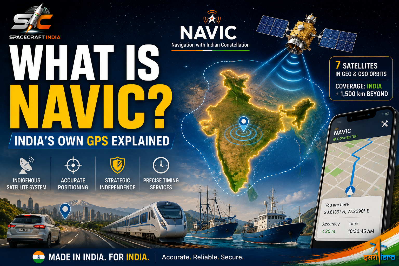
NavIC stands for Navigation with Indian Constellation. It was earlier known as the Indian Regional Navigation Satellite System (IRNSS) before being renamed by Prime Minister Narendra Modi in 2016.
Just as the United States has GPS, Europe has Galileo, Russia has GLONASS, and China has BeiDou, India now has its own independent satellite navigation system called NavIC.
Designed to reduce dependence on foreign navigation systems, NavIC plays a crucial role in civilian transportation, disaster management, defence, fisheries, and emergency response.
Why Did India Develop NavIC?
Before NavIC, India relied primarily on the American Global Positioning System (GPS).
Although GPS is available worldwide, it is controlled by the United States Government. During emergencies or conflicts, access to highly accurate signals may not always be guaranteed.
To ensure strategic independence, ISRO developed NavIC to provide reliable navigation services under Indian control.
NavIC gives India complete ownership of its navigation infrastructure while supporting both civilian and strategic applications.
What Does NavIC Stand For?
NavIC stands for:
Navigation with Indian Constellation
Earlier, the project was officially called:
IRNSS – Indian Regional Navigation Satellite System
The new name, NavIC, is easier to remember and also means “navigator” or “sailor” in Sanskrit, symbolising guidance and direction.
How Does NavIC Work?
NavIC works using a network of satellites orbiting Earth.
These satellites continuously transmit navigation signals to receivers on the ground.
A NavIC-enabled receiver calculates its position by measuring the time taken for signals to arrive from multiple satellites.
The system can accurately determine:
- Current location
- Direction of travel
- Speed
- Accurate time
Unlike GPS, which offers global coverage, NavIC is designed primarily for India and surrounding regions.
How Many Satellites Does NavIC Have?
The NavIC constellation consists of seven primary operational satellites, supported by additional replacement satellites launched over the years to maintain uninterrupted service.
The satellites are placed in:
- Geostationary Orbit (GEO)
- Geosynchronous Orbit (GSO)
This unique configuration ensures excellent signal availability over India.
ISRO continues upgrading the constellation by launching new-generation NavIC satellites with improved capabilities.
Coverage Area
NavIC provides navigation coverage over:
- Entire India
- Approximately 1,500 km beyond India’s borders
This regional focus allows NavIC to deliver highly reliable positioning services where India needs them most.
How Accurate is NavIC?
NavIC offers positioning accuracy of better than 20 metres across most of its service region, with timing accuracy suitable for navigation, telecommunications, banking, and infrastructure applications.
The system provides two services:
Standard Positioning Service (SPS)
Available free for civilian users.
Used for:
- Smartphones
- Vehicle navigation
- Marine navigation
- Public transport
- Personal navigation
Restricted Service (RS)
Encrypted service available only to authorised government and defence users.
Used for:
- Military operations
- National security
- Strategic applications
NavIC vs GPS
Many people ask whether NavIC is better than GPS.
The answer depends on where you are.
| Feature | NavIC | GPS |
|---|---|---|
| Developed by | ISRO | United States |
| Coverage | India + 1,500 km | Global |
| Civilian Service | Yes | Yes |
| Military Service | Yes | Yes |
| Regional Accuracy | Very High | High |
Inside India, NavIC often provides excellent regional coverage because its satellites are specifically positioned for the Indian subcontinent.
GPS, however, remains the preferred choice for worldwide navigation because of its global satellite constellation.
Today, many modern smartphones can use both systems together for improved positioning.
Where is NavIC Used?
NavIC has applications across many sectors.
Road Navigation
Vehicle tracking and digital maps.
Railways
Train tracking and passenger information systems.
Aviation
Supporting navigation and improving flight safety.
Marine Navigation
Helping fishermen safely navigate coastal waters.
Disaster Management
Supporting rescue teams during floods, cyclones, and earthquakes.
Defence
Providing secure navigation during military operations.
Fleet Management
Tracking buses, trucks, ambulances, and logistics vehicles.
NavIC in Smartphones
Several smartphone manufacturers have started supporting NavIC.
Many recent Android smartphones with compatible chipsets can receive NavIC signals alongside GPS, Galileo, GLONASS, and BeiDou.
Using multiple satellite systems improves location accuracy, especially in cities where tall buildings can interfere with satellite signals.
Latest Developments
ISRO continues expanding NavIC through newer satellites equipped with improved navigation payloads.
The latest generation supports additional navigation frequencies, making NavIC easier to integrate into smartphones, automobiles, aviation systems, and commercial navigation devices.
India is also encouraging wider adoption of NavIC across public transportation, emergency services, and consumer electronics.
Why is NavIC Important for India?
NavIC is one of India’s most important strategic space assets.
Its benefits include:
- Navigation independence
- Better national security
- Improved disaster response
- Safer transportation
- Better maritime safety
- Enhanced digital infrastructure
- Reduced dependence on foreign navigation systems
It also demonstrates India’s growing capability in building advanced satellite constellations for national development.
Future of NavIC
The future of NavIC looks promising.
ISRO is expected to:
- Launch more advanced replacement satellites
- Improve positioning accuracy
- Expand compatibility with consumer devices
- Increase adoption in automobiles
- Support autonomous vehicles
- Strengthen aviation and maritime navigation
As India’s digital economy grows, NavIC is expected to become an essential part of everyday life.
Conclusion
NavIC is much more than India’s answer to GPS. It is a symbol of technological self-reliance and a vital component of the country’s space programme.
By providing accurate navigation services across India and neighbouring regions, NavIC supports transportation, defence, disaster management, aviation, fisheries, and countless other applications.
As more smartphones, vehicles, and public services adopt NavIC, millions of Indians will benefit from a navigation system developed and operated entirely by India.
Frequently Asked Questions (FAQs)
What is NavIC?
NavIC (Navigation with Indian Constellation) is India’s indigenous satellite navigation system developed by ISRO to provide accurate positioning, navigation, and timing services across India and neighbouring regions.
Is NavIC better than GPS?
NavIC is designed specifically for India and provides excellent regional coverage. GPS offers global coverage, while NavIC delivers highly accurate positioning within India and approximately 1,500 km beyond its borders.
Can smartphones use NavIC?
Yes. Many modern Android smartphones support NavIC along with GPS, Galileo, GLONASS, and BeiDou. Compatible devices use multiple satellite systems to improve location accuracy.